■Introduction of various tools used in "SURVEY" or "SURVEY WORK":-
As survey work is done in different ways, in the case of newspapers, several tools are also required.
1) Chain:-
A linear measuring device with two handles on both sides made of small iron bars is called chain.
● We usually use the Settlement Gunters chain in land measurement. The length of Gunter's chain is 66 feet and it consists of 100 small links. There is a handle. During the survey, the chain is placed at a specific place by pulling the two handles on both ends. In this way, the length of a place is determined by placing the chain one after the other along the length.
2) Scale:- Various types of scales are used in survey work. Such as cutboard scale, diagonal scale, brass scale etc. Two types of scales are used - 15 cm and 30 cm long. Several types of proportional scales are also used. Both food-inch and millimetre-centimetre measurements are made with cardboard scales.
Also with the help of proportional scales, drawing can be done in different proportions like:- 1:10,1:25,1:50,1:100,1:4000, etc.
3) Divider(compass):- Divider made of brass and nickel has two iron plates with pointers at both ends. The length is determined by measuring any length with the help of two scales and placing it on the scale.
4) Right Angle:- A right angle is a right angle made of metal or wood. This instrument is used if right angles are required while doing survey work in the field.
5)Guniya:- An instrument made of plastic or ivory used to draw offset points perpendicular to the chain line while drawing the design is called Offset Scale, Platting Scale or Guniya.
6) Offset Rod:- The rod used to measure the offset from the chain line to both sides of the chain is called the offset rod.
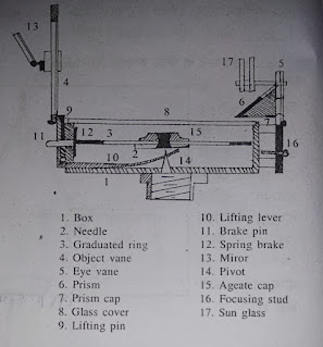
7) Prismatic compass:- The division of the compass is fixed to the north pole or the barium can be read with the help of glass called a prism along with the north-south direction scale is called a prismative compass.
8)Theodolite:- Theodolite is a very accurate and precise measuring instrument. With the help of which we can measure the horizontal angle (Horizontal angle) and vertical angle (Verticle angle) at the same time. Since a telescope is attached to the theodolite, we can also measure distant objects with its help.
Also with the help of theodolite, we can establish the angle of the horizontal, determine the position of a fixed point on a straight line, extend the survey line, twoCan work on determining the difference in height of objects, etc.
There are two types of theodolite- 1) transit theodolite, 2) non-transit theodolite.
9)Length measuring tape:- All the tapes covered with leather and iron covers marked in feet, inches, meters, and centimetres are called measuring tapes. There are two types of tapes.
Cloth tape and steel tape. Usually, 10 meters, 15Meters and 30 meters long ribbons are seen. Two types of scales are drawn on both sides of this ribbon. Meters and centimetres are drawn on one side and feet and inches on the other.
10) North Compass:- The instrument which determines the north and south direction is called Northak compass. This compass is made of a rectangular box. The top of the box is covered with a glass, so that the inside can be seen easily. A shalaka inside or a north shalaka over the privet is in the swing. As this north pole is made of magnets, it always points north-south. Hence, this is north with the help of compass we can determine the north direction of any place in the world.
11) Plane table:- The table on which drawing paper is placed on which the design is drawn is called the plane table. In this method, the survey work of a place and its drawing happen simultaneously. In this method, the size and position of surrounding objects can be easily surveyed with respect to a location. The drawing is done in the field. The plane table is mainly composed of two parts. A wooden table on three legs and a device called "Alidade" for straight sighting and pulling according to the direction.
12)Site Vane:- It is made of wood, brass or steel. It is an essential tool for land surveying. It is used for various purposes. Sight vanes are usually 1ft, 1.5ft or 2ft. Again the telescope sight vane is less than 1 foot. A metal or wooden vessel is fixed at both ends with two sheets of kajja. The first metal sheet i.e. Eyepiece has three holes.
On the other metal sheet i.e. Object piece, there is a gap in the middle and a thread is attached there. A specific direction or position is determined by casting a sight along the thread of the object piece with the eye price. This device is used for various purposes such as sight in places that cannot be surveyed with the help of a chain. Surveys can be done with the help of a vane.
13) Chain Pin:- Every chain interval to keep track of the chain lineA foot long iron rod is buried. These are called chain pins. After two chainmen pull the chain according to the specified station, one pin is buried in each chain.
14)Optical Square:- This small instrument is very necessary for land survey work. With the help of the device, a long line relative to the chain line is determined by measuring the length along the perpendicular line and the distance of the object from the chain is determined. In survey terms, this distance is called the offset distance.
15) Angular scale:- Angular scale is an important material in survey work. of general scale can measure up to a minimum of 1 millimetre with help. But with the help of an angular scale, it is possible to measure up to 1/10 mm. A certain distance can be marked on a Mauza map or any other map with the help of a cut compass or divider and measured on a diagonal or angular scale. If the diagonal scale is metallic, the length of the diagonal scale also varies with temperature. for that, each map has readings on a diagonal scale. As a result, the distance can be determined from the map with the help of that diagonal scale throughout the year.
16) Field Book:- Field book is a special book which is required during a field survey. The information obtained during the field survey should be recorded in the field book. Later, all that information must be identified as necessary.
Field books are generally of two types, 1) one-line field book and 2) two-line field book. If there is a spot in the middle of the field book, the line is called a field book. If there are two spots in the middle of the field book, it is called a double line field-book. two linesChain distance, offset distance etc. can be shown separately in the flow book. For that two-line flow book is mostly used.
17) Three-leg table:- A longboard made of wood is placed on three legs. This table is a very important tool in land surveying. This table has three legs and the board can be separated as needed. As a result, it can easily be carried from one place to another goes The legs are also made with screws so that the table can be raised and lowered as required by removing the legs.
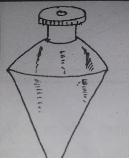
18) Woolen:- Woolen is an essential material in survey work. For centering the table to a specific point, the help of an angle is required. That is, we can check whether a certain point on the surface of a table is perpendicular to a station. Wool is actually a piece of metal strung on a thin thread. When the block is released, the thread is perpendicular to the surface at 90°.
19) Spirit Level:- Place the table at a specific station and see if the top of the table is below the horizontal. We bring a table down to the horizontal with the help of a spirit level. A spirit level is a glass tube filled with spirit. Wherever the table is higher the spirit rises. And when the table is below the horizon, the spirit is right in the middle.
20)Set square:-Two triangular rules are used for drawing designs. One of them has angles of 90°, 45° and 45° and the other has angles of 90°, 60° and 30°. This triangular rule is called a set square. With the help of a set square, we can draw perpendicular or 30°, 60° or 45° angles at a specific point on a straight line.
21)Pencil Compass:- A compass that looks like a cut compass or divider and has a pencil at one end and a pencil at the other end is called a pencil compass. With the help of a pencil compass, we can draw a circle or arc centered on a certain point.
22) Subscription:-With the help of a subscription we can draw the map with a compass survey bearing. An angle of any measure can be drawn at a given point with a circular subscript.
Written by Mrityunjoy Saha
Picture collection Mrityunjoy Saha


Thank you for getting in touch with us (KSI BLOG)